
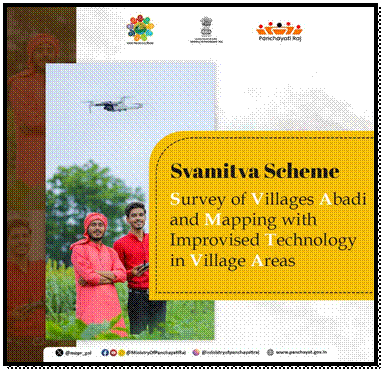
- SVAMITVA was launched in April 2020 to give rural residents legal ownership records for their residential properties through drone-based mapping.
- The scheme is implemented by the Ministry of Panchayati Raj, with support from the Survey of India and National Informatics Centre Services Inc. (NICSI).
- Under the scheme, drone surveys are used to accurately map properties in rural villages and issue property cards to the owners.
- These property cards can help people prove ownership, access bank loans, settle property disputes, and support better village planning.
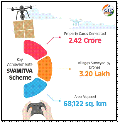
- So far, more than 2.42 crore property cards have been issued covering 1.61 lakh villages.
- Drone surveys have been completed in around 3.20 lakh villages, covering about 68,122 sq. km. of area.
The SVAMITVA (Survey of Villages and Mapping with Improvised Technology in Village Areas) Scheme was launched by the Prime Minister on 24 April 2020, on National Panchayati Raj Day. The scheme completed its 5th anniversary in 2025.
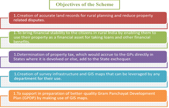
The main aim of SVAMITVA is to give legal ownership documents to people for the houses and residential land they occupy in villages. Drones and modern mapping technology are used to accurately survey properties and identify their boundaries.
Why is SVAMITVA Important?
With a proper property card, rural residents can:
- Prove legal ownership of their property.
- Use their property as an asset for obtaining bank loans.
- Resolve property-related disputes more easily.
- Make better use of their property for economic activities.
- Help local authorities with better village planning and development.
Implementation & Cost
The Survey of India (SoI) is responsible for implementing the scheme, while National Informatics Centre Services Inc. (NICSI) acts as the technology partner. The scheme has a total financial outlay of ₹566.23 crore for FY 2020-21 to FY 2024-25, with the scheme extended up to FY 2025-26. SVAMITVA uses drones + digital mapping + property cards to give rural families clearer proof of property ownership and support better village development.
Key Achievements Under Scheme
- Property Cards Distribution:
- On 18 January 2025, around 65 lakh SVAMITVA property cards were distributed to rural residents across more than 50,000 villages. This covered 10 states—Chhattisgarh, Gujarat, Himachal Pradesh, Madhya Pradesh, Maharashtra, Mizoram, Odisha, Punjab, Rajasthan and Uttar Pradesh—and 2 Union Territories: Jammu & Kashmir and Ladakh.
- Drone Surveys:
- As of 2 April 2025, drone surveys had been completed in about 3.20 lakh villages under SVAMITVA. The surveys covered an estimated 68,122 sq. km. of rural inhabited areas.
- Progress Across States and UTs:
- As of 11 March 2025, 31 States and Union Territories had signed MoUs for implementing the scheme. Drone surveys had been completed in 3.20 lakh villages, with 100% coverage achieved in Lakshadweep, Ladakh, Delhi, Andhra Pradesh, Madhya Pradesh, Uttar Pradesh and Chhattisgarh.
Around 2.42 crore property cards had been issued, covering 1.61 lakh villages. SVAMITVA is helping rural families get official property records through drone surveys, making property ownership clearer and supporting loans, dispute resolution and better village planning. SVAMITVA is gaining international attention for using modern technology to improve land ownership and management in rural areas. Its approach shows how tools like drones and digital maps can make property records more accurate and transparent.
- International Workshop on Land Governance:
- An International Workshop on Land Governance was held from 24–29 March 2025 at the Haryana Institute of Public Administration (HIPA), Gurugram. Senior officials from 22 countries participated. The workshop highlighted India’s use of drone surveys, digital property records and transparent land governance through the SVAMITVA Scheme.
- India International Trade Fair 2024:
- At the India International Trade Fair 2024 at Bharat Mandapam, SVAMITVA showcased how drones and GIS mapping can help rural residents get clear and legally recognised property records. This can help reduce property disputes, improve access to bank credit and support economic opportunities for rural communities.
SVAMITVA shows how technology + accurate property records + transparent governance can strengthen property rights and support rural development.
Why Was the SVAMITVA Scheme Needed?
For many years, village houses and residential land were not properly recorded. Because people often did not have official property documents, they faced difficulties in proving ownership, getting bank loans, and accessing certain government benefits.
The lack of clear property records also caused land disputes and made it difficult to plan rural development properly.
The SVAMITVA Scheme was introduced to address these problems. It provides rural residents with official property cards that recognise their ownership. This gives people greater security over their property and allows them to use it as an economic asset, helping improve livelihoods and support rural development. SVAMITVA helps turn unrecorded village properties into officially recognised assets, giving rural families stronger property rights and better economic opportunities.
SVAMITVA Components
The SVAMITVA Scheme uses modern technology, digital mapping and public awareness to create accurate property records in rural areas. Its major components are:
1. CORS Network
Continuously Operating Reference Stations (CORS) help establish accurate Ground Control Points. These points are used to correctly locate and mark properties on digital maps.
2. Drone-Based Mapping
The Survey of India uses drones to survey village residential areas (abadi areas). Drones create high-resolution and accurate maps showing property boundaries. Based on these maps, property cards are issued to rural property owners.
3. Awareness Programmes
Through Information, Education and Communication (IEC) activities, villagers are informed about the scheme, the survey process and the benefits of getting official property records.
4. Improving Gram Manchitra
The digital maps created through drone surveys are used to improve Gram Manchitra, a spatial planning tool. This helps Gram Panchayats prepare better Gram Panchayat Development Plans (GPDPs) and plan local development projects.
5. Online Monitoring
An online dashboard is used to regularly track the progress of surveys, mapping, property-card distribution and other activities under the scheme.
6. Project Management
Programme Management Units (PMUs) have been established at the national and state levels. They help the Ministry and state governments with the planning, coordination and implementation of the scheme.
SVAMITVA combines CORS technology, drones, digital maps, public awareness and online monitoring to create accurate property records and support better rural planning.
How SVAMITVA Is Helping Rural Families
The SVAMITVA Scheme is helping rural people by giving them clear proof of property ownership. This can reduce land disputes, make it easier to access financial services and improve the overall management of village land.
1. Helping Resolve Property Disputes
Smt. Sunita from Taropka village, Himachal Pradesh, had faced uncertainty over her ancestral property for around 25 years. Through SVAMITVA, she received a property card confirming her ownership.
This document helped her resolve a long-standing dispute with her neighbour and gave her family greater security over their property.
2. Improving Access to Bank Loans
Sh. Sukhlal Pargi from Falated village, Rajasthan, received a Patta and Property Card under the SVAMITVA Scheme. These documents helped him access formal financial services.
Using his property documents, he was able to obtain a ₹3 lakh bank loan. This shows how having official property records can help rural families use their property as a financial asset.
SVAMITVA is helping villagers prove what they own, settle property disputes and access formal credit. By turning property into a legally recognised asset, the scheme can contribute to greater financial security and rural development.
Conclusion
The SVAMITVA Scheme is bringing a major change in the way property ownership is managed in rural India. For years, unclear property records and boundary disputes created problems for rural families. By using drones, digital mapping and property cards, the scheme is helping people get clear and official records of the properties they own.
The benefits go beyond simply providing a property document. Clear ownership can help people resolve disputes, access bank loans and use their property as an economic asset. At the same time, accurate digital maps can help Panchayats plan roads, infrastructure and other development activities more effectively.
SVAMITVA also shows how technology can be used to solve long-standing rural problems. By combining modern surveying techniques with transparent property records, it is helping create greater clarity and security for rural households.
In the long run, the scheme can contribute to better land management, stronger financial inclusion, improved village planning and greater economic opportunities. In simple terms, SVAMITVA is not just about mapping land—it is about giving rural families clearer property rights and creating a stronger foundation for rural development and self-reliance.