
Agro Climatic Zones
To get the best possible crop production from the available land, water, and climate, farmers need technologies and farming methods that are suitable for their local conditions. Since different parts of India have different soils, rainfall patterns, temperatures, and water availability, the same farming practices cannot be used everywhere.
To solve this, the Planning Commission divided the country into Agro-Climatic Zones in 1989. This classification was based on factors such as land characteristics, soil type, climate, rainfall, and agricultural conditions.
An Agro-Climatic Zone is an area that has similar climate and natural conditions, making it suitable for growing a specific group of crops. This helps in planning agriculture more effectively by recommending the right crops, farming techniques, and resource management practices for each region.
The main objective of agro-climatic planning is to ensure sustainable agricultural development. It aims to meet the country’s needs for food, fibre, fodder, and fuelwood while conserving natural resources like soil, water, and forests and protecting the environment.
The major agro-climatic factors include soil type, rainfall, temperature, and water availability, as these determine which crops and vegetation can grow successfully in a particular area.
Agro-Ecological Zone
An Agro-Ecological Zone (AEZ) is a smaller and more detailed agricultural region than an agro-climatic zone. It is created by combining climate with land features (landforms), soil characteristics, and the length of the growing period (the number of days when crops can grow due to sufficient moisture and suitable temperature). This helps identify the most suitable crops and farming practices for a specific area.
India has a wide variety of mountains, plains, plateaus, deserts, coastal areas, and islands. Because of these geographical differences, every region has its own climate, rainfall, temperature, and soil conditions, which influence the types of crops that can be grown successfully.
Delineation of Agro-Climatic Regions
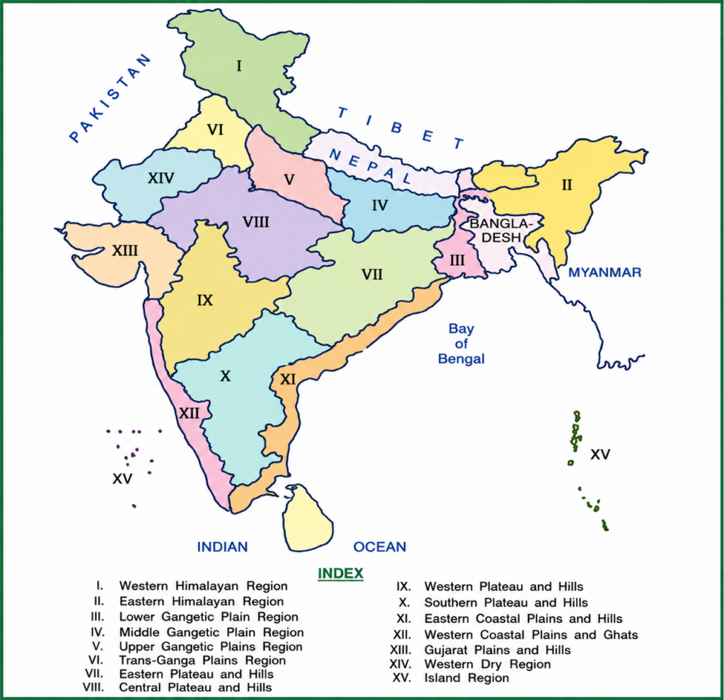
To promote balanced agricultural development, the Planning Commission, along with the National Remote Sensing Agency (NRSA), divided India into 15 Agro-Climatic Regions in 1989. While identifying these regions, factors such as climate, landforms, soil, water resources, and socio-economic conditions were considered.
Objectives of Agro-Climatic Regional Planning
The main goals of dividing India into agro-climatic regions are:
- Increase agricultural production by promoting suitable crops and technologies.
- Improve farmers’ income through efficient use of resources.
- Create more employment opportunities in rural areas.
- Use irrigation water efficiently and avoid wastage.
- Reduce regional disparities in agricultural development and ensure balanced growth across the country.
The 15 Agro-Climatic Regions of India
- Western Himalayan Region
- Eastern Himalayan Region
- Lower Gangetic Plains Region
- Middle Gangetic Plains Region
- Upper Gangetic Plains Region
- Trans-Gangetic Plains Region
- Eastern Plateau and Hills Region
- Central Plateau and Hills Region
- Western Plateau and Hills Region
- Southern Plateau and Hills Region
- East Coast Plains and Hills Region
- West Coast Plains and Ghats Region
- Gujarat Plains and Hills Region
- Western Dry Region
- The Islands Region
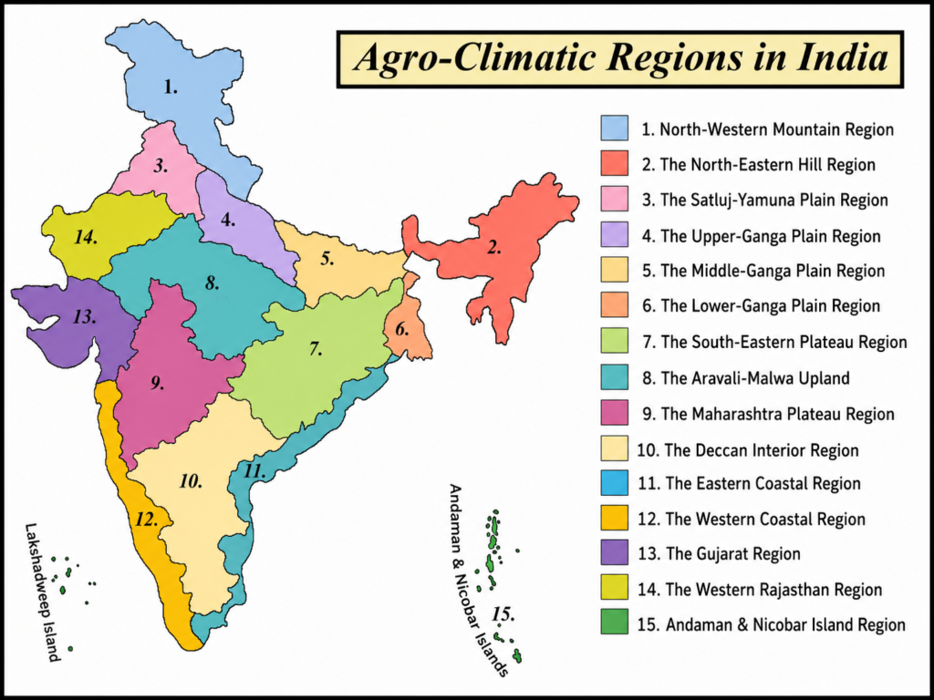
Agro Climatic Zones of India
I. Western Himalayan Region
Location and Topography
The Western Himalayan Region includes Jammu & Kashmir, Himachal Pradesh, and the hilly areas of Uttarakhand. This region is known for its snow-covered mountains, steep slopes, deep valleys, fast-flowing rivers, and dense evergreen and deciduous forests. The soil is generally shallow and found on uneven mountain slopes, making farming difficult.
Climate
The climate varies from one place to another because of differences in altitude. Summers are pleasant, with temperatures ranging from 5°C to 30°C, while winters are extremely cold, with temperatures between 0°C and -4°C. Heavy snowfall and harsh winter weather limit farming activities and shorten the growing season.
Agriculture
Farming is mainly carried out in valleys, river terraces, and gentle hill slopes, where the land is relatively flat. During the Kharif season, rice is grown in the valleys, while maize is the main crop in hilly areas.
In the Rabi season, farmers grow wheat, barley, oats, and peas. However, these crops grow slowly during winter because temperatures often fall below the freezing point.
This region is also famous for its fruit orchards. It produces high-quality apples, especially in Sopore, Srinagar, Baramulla, Kullu-Manali, Shimla, Kangra, Ranikhet, and Almora. Other important fruits and crops grown here include apricot, almond, walnut, cherry, peach, pear, litchi, loquat, and saffron.
The high-altitude grasslands, locally called Dhoks or Margs, provide grazing land for sheep, goats, cattle, and horses. Communities such as the Gujjars, Bakarwals, and Gaddis depend on these pastures for livestock rearing.
Socio-Economic Features and Suggestions
Agriculture is the main source of livelihood in this region, and more than 80% of the population depends directly or indirectly on farming.
However, farmers face several challenges, including:
- Poor road connectivity and transport facilities.
- Soil erosion and frequent landslides.
- Harsh weather conditions.
- Lack of proper storage and marketing facilities for agricultural produce.
Because of these problems, the region’s agricultural potential has not been fully utilized. Many farmers also have limited access to modern farming technologies, such as High Yielding Variety (HYV) seeds.
To improve agriculture in this region, there is a need for:
- Better agricultural research and extension services.
- Improved roads, storage, and marketing infrastructure.
- Adoption of modern farming techniques.
- Soil and water conservation measures.
- Greater support for horticulture and livestock farming.
These steps can help increase farmers’ income, improve productivity, and promote sustainable agricultural development in the Western Himalayan Region.
II. Eastern Himalayan Region
Location and Topography
The Eastern Himalayan Region includes Arunachal Pradesh, Sikkim, Meghalaya, Nagaland, Manipur, Mizoram, Tripura, the hilly areas of Assam, and the Darjeeling district of West Bengal. The region is mainly made up of hills and mountains with steep and uneven terrain, making farming difficult in many places.
Climate
The region has a warm and humid climate. During July, temperatures usually range from 25°C to 30°C, while in January they remain between 10°C and 20°C. It receives heavy rainfall of about 200–400 cm every year, making it one of the wettest regions in India. The soil is mostly red-brown, but it is not very fertile. In many hilly areas, farmers still practice Jhum cultivation (shifting cultivation).
Agriculture
The major crops grown in this region are rice, maize, potato, and tea. The region is also famous for fruit cultivation, especially pineapple, orange, litchi, and lime. Tea plantations are an important source of income in several parts of the region.
Socio-Economic Features and Suggestions
Agriculture is the main livelihood for a large part of the population. However, poor roads, limited transport, and inadequate infrastructure affect agricultural growth.
To improve farming in this region:
- Better roads, storage, and irrigation facilities should be developed.
- Jhum cultivation should be gradually replaced with terrace farming, which helps conserve soil and increases crop productivity.
- Farmers should be encouraged to adopt modern farming techniques and better crop management practices.
III. Lower Gangetic Plain Region
Location and Topography
The Lower Gangetic Plain Region includes West Bengal (except its hilly areas), eastern Bihar, and the Brahmaputra Valley. The region has fertile plains with abundant groundwater and a high water table, making it highly suitable for agriculture.
Climate
This region receives 100–200 cm of rainfall annually, which supports crop cultivation throughout the year. Summer temperatures range from 26°C to 41°C, while winter temperatures remain between 9°C and 24°C.
Agriculture
Rice is the most important crop of this region. In many places, farmers grow three rice crops in a year—Aman, Aus, and Boro. Other major crops include jute, maize, potato, and pulses.
The fertile soil, adequate water supply, and favorable climate make this region one of India’s most productive agricultural areas.
Socio-Economic Features and Suggestions
To further improve agriculture in this region, efforts should focus on:
- Increasing rice productivity through better farming practices.
- Promoting horticulture, especially the cultivation of banana, mango, and citrus fruits.
- Encouraging fish farming (pisciculture), poultry farming, and livestock rearing to provide additional income to farmers.
- Expanding fodder production and ensuring the availability of quality seeds for higher crop yields.
These measures can help increase farmers’ income, improve food production, and support sustainable agricultural development.
IV. Middle Gangetic Plain Region
Location and Topography
The Middle Gangetic Plain Region covers large parts of Uttar Pradesh and Bihar. It is a fertile alluvial plain formed by the deposits of the Ganga River and its tributaries. The fertile soil and abundant water resources make this region one of India’s major agricultural areas.
Climate
The region has a favourable climate for farming. During July, temperatures range from 26°C to 41°C, while in January, they range between 9°C and 24°C. It receives 100–200 cm of rainfall annually, which supports the cultivation of a variety of crops.
Agriculture
Agriculture is the main occupation in this region.
Major Kharif (Monsoon) crops:
- Rice
- Maize
- Millets
Major Rabi (Winter) crops:
- Wheat
- Gram
- Barley
- Peas
- Mustard
- Potato
The fertile soil and favourable climate allow farmers to grow multiple crops throughout the year.
Socio-Economic Features and Suggestions
To improve agricultural productivity and farmers’ income, the following measures are recommended:
- Promote alternative farming systems, such as integrating crop cultivation with fisheries and livestock.
- Use chaur lands (low-lying waterlogged areas) for fish farming (pisciculture).
- Reclaim wastelands, degraded lands, and fallow lands for agriculture and allied activities like agroforestry, forestry, and floriculture.
- Encourage better land and water management to make farming more productive and sustainable.
These steps can increase crop production, create additional income opportunities, and improve the livelihoods of farmers.
V. Upper Gangetic Plains Region
Location and Topography
The Upper Gangetic Plains Region includes the central and western parts of Uttar Pradesh along with the Haridwar and Udham Singh Nagar districts of Uttarakhand. It is a fertile plain with good irrigation facilities, making it one of India’s most productive agricultural regions.
Climate
The region has a sub-humid continental climate. Summer temperatures range from 26°C to 41°C, while winter temperatures vary between 7°C and 23°C. The average annual rainfall is 75–150 cm, which is sufficient for growing a wide range of crops.
Agriculture
The soil is mainly sandy loam, which is suitable for agriculture. Farmers depend on canals, tube wells, and wells for irrigation.
The major crops grown in this region are:
- Wheat
- Rice
- Sugarcane
- Millets
- Maize
- Gram
- Barley
- Oilseeds
- Pulses
- Cotton
Due to fertile soil and reliable irrigation, the region practices intensive agriculture, producing large quantities of food grains and cash crops.
Socio-Economic Features and Suggestions
To further improve agriculture in this region, the following measures should be taken:
- Modernize traditional farming by adopting improved technologies and better farming practices.
- Promote dairy farming to provide farmers with an additional source of income.
- Encourage horticulture, including fruit and vegetable cultivation.
- Adopt multiple and mixed cropping systems to increase productivity, reduce farming risks, and make better use of land and water resources.
These measures can improve farmers’ income, increase agricultural productivity, and ensure sustainable agricultural development in the Upper Gangetic Plains Region.
VI. Trans-Ganga Plains Region
Location and Topography
The Trans-Ganga Plains Region, also known as the Sutlej–Yamuna Plains, includes Punjab, Haryana, Chandigarh, Delhi, and the Ganganagar district of Rajasthan. It has fertile alluvial soil, which is ideal for agriculture.
Climate
The region has a semi-arid climate. Summer temperatures range from 25°C to 40°C, while winter temperatures remain between 10°C and 20°C. It receives 65–125 cm of rainfall annually. Farmers have access to good irrigation facilities through canals, tube wells, and pumping sets, which support year-round farming.
Agriculture
This region has the highest agricultural intensity in India. Major crops grown here include:
- Wheat
- Rice
- Sugarcane
- Cotton
- Gram
- Maize
- Millets
- Pulses
- Oilseeds
The Green Revolution began in this region, making it one of the most productive farming areas in the country. Farmers widely use modern machinery, improved seeds, fertilizers, and irrigation techniques.
However, the region also faces several challenges such as:
- Waterlogging
- Soil salinity and alkalinity
- Soil erosion
- Declining groundwater levels due to excessive water use.
Socio-Economic Features and Suggestions
To make agriculture more productive and sustainable, the following measures are recommended:
- Reduce excessive rice-wheat cultivation and encourage crops like maize, pulses, oilseeds, and fodder crops.
- Develop crop varieties that are resistant to pests and diseases.
- Promote horticulture and pulse cultivation, especially in upland areas.
- Encourage vegetable farming near cities and industrial areas.
- Provide farmers with quality seeds and planting materials.
- Build better storage, processing, and transportation facilities for fruits and vegetables.
- Improve milk and wool production through better livestock management.
- Increase fodder production and improve animal feed to support dairy farming.
These steps will help conserve natural resources while maintaining high agricultural productivity.
VII. Eastern Plateau and Hills Region
Location and Topography
The Eastern Plateau and Hills Region includes the Chotanagpur Plateau and extends across Jharkhand, Odisha, Chhattisgarh, and the Dandakaranya region. The area mainly consists of plateaus and hills, with many seasonal rivers. Because most rivers are not perennial, water availability is often limited.
Climate
The climate is warm throughout most of the year. Summer temperatures range from 26°C to 34°C, while winter temperatures remain between 10°C and 27°C. The region receives 80–150 cm of annual rainfall, but water shortages are common because rainwater quickly flows away from the plateau areas.
Agriculture
The soils are mainly red and yellow, with some laterite and alluvial soils. Since irrigation facilities are limited, farming is mostly rain-fed.
The major crops grown are:
- Rice
- Millets
- Maize
- Oilseeds
- Ragi
- Gram
- Potato
Agriculture in this region largely depends on the monsoon, making crop production vulnerable to rainfall variations.
Socio-Economic Features and Suggestions
To improve agricultural productivity and increase farmers’ income, the following measures are suggested:
- Promote high-value crops such as tur (pigeon pea), soybean, and groundnut in rain-fed upland areas.
- Grow urad, castor, and groundnut during the Kharif season, and mustard and vegetables in irrigated fields.
- Improve local breeds of cattle and buffaloes to increase milk production.
- Expand fruit orchards to diversify farmers’ income.
- Renovate existing ponds and tanks, remove silt, and build new water storage structures.
- Promote inland fish farming in permanent water bodies.
- Adopt integrated watershed management to conserve soil, harvest rainwater, and improve water availability.
These measures can help make farming more productive, improve water conservation, and provide better livelihoods for farmers in the region.
VIII. Central Plateau and Hills Region
Location and Topography
The Central Plateau and Hills Region includes Bundelkhand, Baghelkhand, the Bhander Plateau, the Malwa Plateau, and the Vindhyachal Hills. The region consists of plateaus and hilly areas with different types of soils, mainly red, yellow, and black soils.
Climate
The region has a semi-arid climate. Summer temperatures range from 26°C to 40°C, while winter temperatures remain between 7°C and 24°C. It receives 50–100 cm of rainfall annually, which is often not enough for intensive farming. Water scarcity is a major challenge.
Agriculture
Because of limited water availability, farmers mainly grow crops that require less water. The major crops are:
- Millets
- Wheat
- Gram
- Oilseeds
- Cotton
- Sunflower
Agriculture in this region depends heavily on rainfall, making crop production uncertain in dry years.
Socio-Economic Features and Suggestions
To improve agricultural productivity and farmers’ income, the following measures are recommended:
- Promote water conservation by using drip irrigation and sprinkler irrigation.
- Encourage dairy farming to provide an additional source of income.
- Promote crop diversification by introducing more profitable crops.
- Improve groundwater development for better irrigation.
- Reclaim ravine and degraded lands so they can be used for agriculture.
These measures can help farmers use water more efficiently and make agriculture more sustainable.
IX. Western Plateau and Hills Region
Location and Topography
The Western Plateau and Hills Region covers the southern part of the Malwa Plateau and the Deccan Plateau in Maharashtra. The region is famous for its black cotton soil (regur soil), which is highly suitable for crops like cotton.
Climate
The climate is generally warm and dry. Summer temperatures range from 24°C to 41°C, while winter temperatures remain between 6°C and 23°C. The region receives 25–75 cm of rainfall annually, making many areas dependent on rain-fed agriculture.
Agriculture
In rain-fed areas, the major crops grown are:
- Wheat
- Gram
- Millets
- Cotton
- Pulses
- Groundnut
- Oilseeds
In irrigated areas, farmers grow:
- Sugarcane
- Rice
- Wheat
The region is also well known for the cultivation of fruits such as oranges, grapes, and bananas.
Socio-Economic Features and Suggestions
To improve agricultural income and conserve water, the following measures are suggested:
- Increase water-use efficiency through drip and sprinkler irrigation.
- Replace low-value crops like jowar, bajra, and rain-fed wheat with high-value oilseed crops.
- Encourage fruit cultivation such as ber, pomegranate, mango, and guava in suitable areas.
- Improve milk production through cross-breeding of cattle and buffaloes.
- Promote poultry farming to provide additional income to farmers.
These measures can make agriculture more profitable and sustainable.
X. Southern Plateau and Hills Region
Location and Topography
The Southern Plateau and Hills Region lies in the interior Deccan Plateau and covers parts of southern Maharashtra, Karnataka, Andhra Pradesh, and the upland areas of Tamil Nadu, extending from Adilabad in the north to Madurai in the south.
Climate
The region has a warm climate throughout the year. Summer temperatures range from 25°C to 40°C, while winter temperatures remain between 10°C and 20°C. The average annual rainfall is 50–100 cm, so much of the agriculture depends on seasonal rainfall.
Agriculture
This is mainly a dry farming region. The major crops grown are:
- Millets
- Oilseeds
- Pulses
The hilly areas of Karnataka are famous for plantation crops such as:
- Coffee
- Tea
- Cardamom
- Other spices
These plantation crops contribute significantly to the region’s economy.
Socio-Economic Features and Suggestions
To improve agriculture and farmers’ livelihoods, the following measures are recommended:
- Replace some coarse cereals with more profitable pulses and oilseeds.
- Promote horticulture by encouraging fruit and vegetable cultivation.
- Strengthen dairy farming to increase farmers’ income.
- Encourage poultry farming as an additional source of livelihood.
These steps can improve agricultural productivity, increase farmers’ earnings, and make farming more sustainable in the Southern Plateau and Hills Region.
XI. Eastern Coastal Plains and Hills Region
Location and Topography
The Eastern Coastal Plains and Hills Region includes the Coromandel Coast and the Northern Circars of Andhra Pradesh and Odisha. It consists of fertile coastal plains along with some hilly areas.
Climate
The region has a warm and humid climate. Summer temperatures range from 25°C to 35°C, while winter temperatures remain between 20°C and 30°C. It receives 75–150 cm of annual rainfall, which supports agriculture.
Agriculture
The soils are mainly alluvial, loam, and clay, although some areas face the problem of soil alkalinity.
The major crops grown are:
- Rice
- Jute
- Tobacco
- Sugarcane
- Maize
- Millets
- Groundnut
- Oilseeds
These crops form the backbone of agriculture in the region.
Socio-Economic Features and Suggestions
To improve agriculture and farmers’ income, the following measures are recommended:
- Promote the cultivation of spices such as pepper and cardamom.
- Develop fisheries as an additional source of livelihood.
- Increase cropping intensity by using water-efficient crops.
- Replace rice with oilseeds and pulses on less productive lands.
- Encourage crop diversification instead of growing the same crop repeatedly.
- Promote horticulture, social forestry, and dairy farming.
These measures will improve productivity, conserve resources, and increase farmers’ income.
XII. Western Coastal Plains and Ghats Region
Location and Topography
The Western Coastal Plains and Ghats Region includes the Konkan Coast, Malabar Coast, and the Western Ghats (Sahyadri Hills). The region has a long coastline, fertile plains, and forest-covered hills.
Climate
The climate is hot, humid, and receives heavy rainfall. Summer temperatures range from 25°C to 30°C, while winter temperatures remain between 18°C and 30°C. The region receives more than 200 cm of rainfall every year, making it one of the wettest parts of India.
Agriculture
The soils are mainly laterite and coastal alluvial soils.
The important crops grown in this region are:
- Rice
- Coconut
- Oilseeds
- Sugarcane
- Millets
- Pulses
- Cotton
The Western Ghats are also famous for plantation crops and spices such as coffee, tea, pepper, cardamom, and other spices.
Socio-Economic Features and Suggestions
To improve agriculture in this region, the following steps should be taken:
- Promote high-value crops like spices, pulses, and coconut.
- Improve roads, storage, and marketing facilities.
- Encourage prawn farming in brackish water areas.
- Strengthen plantation agriculture and fisheries.
These measures can increase farmers’ income and support sustainable agricultural development.
XIII. Gujarat Plains and Hills Region
Location and Topography
The Gujarat Plains and Hills Region includes the Kathiawar Peninsula and the fertile valleys of the Mahi and Sabarmati rivers. The region has both plains and hilly areas and experiences arid to semi-arid climatic conditions.
Climate
The average summer temperature is around 30°C, while winter temperatures remain around 25°C. The region receives 50–100 cm of annual rainfall, which is moderate but unevenly distributed.
Agriculture
The region has different types of soils:
- Black (regur) soil in the plateau areas.
- Alluvial soil in the coastal plains.
- Red and yellow soils in the Jamnagar region.
The major crops grown are:
- Groundnut
- Cotton
- Rice
- Millets
- Oilseeds
- Wheat
- Tobacco
This region is one of India’s leading oilseed-producing regions.
Socio-Economic Features and Suggestions
To improve agriculture, the following measures are suggested:
- Manage canal and groundwater resources efficiently.
- Promote rainwater harvesting.
- Encourage dryland farming techniques.
- Develop agroforestry and reclaim wastelands.
- Expand marine fisheries and brackish water aquaculture along coastal areas and river deltas.
These measures can improve water use, increase productivity, and provide additional income opportunities for farmers.
XIV. Western Dry Region
Location and Topography
The Western Dry Region covers the western part of Rajasthan, located west of the Aravalli Hills. It is mainly a desert region with sandy soil and very little rainfall.
Climate
The region has an extremely hot and dry climate. It receives less than 25 cm of rainfall annually, making it one of the driest regions in India.
Summer temperatures can reach 28°C to 45°C, while winter temperatures range from 5°C to 22°C. High evaporation and irregular rainfall make farming very challenging.
Agriculture
Farming mainly depends on the limited rainfall available.
The major crops are:
- Kharif crops: Bajra, jowar, and moth bean.
- Rabi crops: Wheat and gram.
Livestock rearing is an important part of the local economy, as many people depend on cattle, sheep, goats, and camels for their livelihood.
Socio-Economic Features and Suggestions
To improve agriculture and rural livelihoods, the following measures are recommended:
- Promote rainwater harvesting to store water for farming.
- Increase the production of horticultural crops such as watermelon, guava, and date palm.
- Improve livestock breeds by introducing high-quality germplasm.
- Develop silvi-pastoral systems, which combine trees with pasture, on wastelands to improve fodder availability and prevent land degradation.
These measures can help farmers use scarce water efficiently, improve crop production, and strengthen livestock-based livelihoods in the desert region.
XV. Island Region
Location and Topography
The Island Region includes the Andaman & Nicobar Islands in the Bay of Bengal and the Lakshadweep Islands in the Arabian Sea. These islands have an equatorial climate, which means they remain warm and humid throughout the year. The region is covered with dense forests and surrounded by the sea.
Climate
The climate is warm and humid with heavy rainfall of up to 300 cm annually. In Port Blair, the average temperature is around 30°C in July and 25°C in January. The weather remains pleasant with very little variation in temperature throughout the year.
Agriculture
The soils vary from sandy soils along the coast to clayey loam soils in valleys and lower slopes.
The major crops grown in this region are:
- Rice
- Maize
- Millets
- Pulses
- Areca nut
- Turmeric
- Cassava
Coconut is the most important crop, occupying nearly half of the cultivated land. Since a large part of the islands is covered by forests, agriculture is still not highly developed compared to mainland India.
Socio-Economic Features and Suggestions
To improve agriculture and the overall economy of the island region, the following measures are recommended:
- Improve crop productivity by introducing high-yielding and improved varieties of seeds, especially rice.
- Encourage farmers to grow two rice crops a year instead of one wherever possible.
- Promote better water management to ensure efficient use of available water resources.
- Strengthen the fisheries sector by introducing modern fishing vessels for deep-sea fishing.
- Develop proper fish storage, processing, and marketing facilities.
- Encourage brackish water prawn farming in coastal areas to generate additional income.
These measures can help increase agricultural production, improve fisheries, create employment opportunities, and support the sustainable development of the Island Region.